
Maps were once used exclusively to find the best roads, the nearest gas stations, and other important landmarks. However, thanks to the internet, these useful inventions can now teach you a whole lot more about a country than you might have imagined. With so much data available to us nowadays, maps can be a marvelous visual tool for sharing information that’s shocking, brilliant, or simply tremendously silly.
Indeed, even individuals who have spent their whole lives in the United States of America will be stunned to realize what a couple of clever maps can reveal to them. Prepare to laugh out loud as these hilarious maps show you a creative side of the US that you’ve never seen before.
Sexy Halloween Costumes By State
Have you ever wondered which sexy Halloween costume would suit each state? Neither had we. However, now that the idea is in our heads, we’re intrigued! Check out the map below and see if you agree with each state’s costume choice.
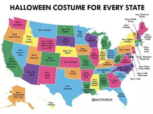
Some of them work, but some are a bit extreme. It’s no secret that Washington State rains a ton, so why not be a steamy umbrella for Halloween? That works. However, Ohio’s attractive jobless individual is just cruel.
The Popularity of Pop Music
Indeed, change is the only constant in this world. Until checking this awesome map thoroughly, we believed that roughly the same popular music was being played continually in every state. Now, we’re not so sure.
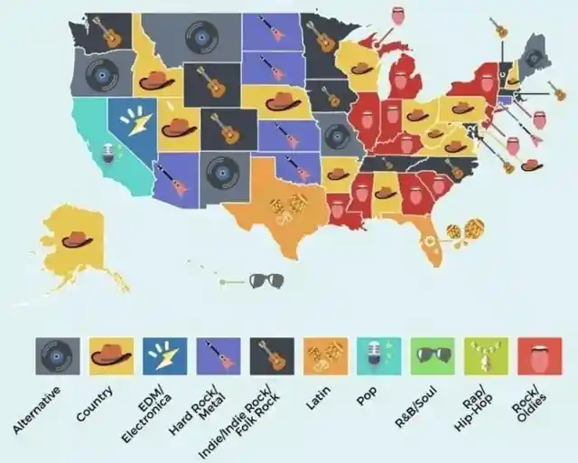

As per this photograph, people are considerably more into country music and rock/oldies. Surprisingly, the lone state that is by all accounts playing popular music, is California. This map can’t be correct. We don’t know anyone who’s not into pop music. Either way, the illustrations are marvelous!
A Terrible Dad Joke
You don’t need to be a virtuoso to understand what’s happening here. The individual who made this map was clearly a father since this photograph is an ideal illustration of a terrible dad joke. Still, a bad joke is better than no joke at all. Now more than ever, we could use something to paint a smile on our faces.
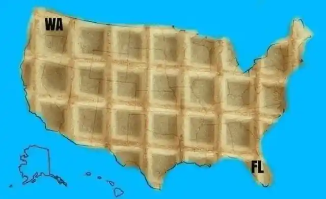

There’s no better source for lol moments than that extraordinary sense of humor shared by dads all over the world. So this dad believed it was amusing to write the initials of Washington and Florida states on a US map and make the whole country look like a waffle to match the WAFL initials. Cue the eye rolls.
The Most Dangerous State in America?
Whoever made this map is obviously under the impression that Indiana is the riskiest state out of each of the 50 states in the United States. Why is that so?

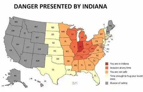
As indicated by the map, states that are near Indiana are still perilous, and the ones further back are shaded dark, having an “illusion of safety” (since Indiana is still nearby). The person behind this map had better maintain their anonymity to avoid trouble. Maybe the map designer had some issues with this state in the past?
The Most Confusing Map
We bet you’ll agree with us when we say that at first sight, this map is extremely befuddling. However, don’t stress – we will clarify what’s going on. The individual who planned this was attempting to be clever.


If you have the patience to read what the words say from left to right, it’ll tell you that these state maps aren’t that meaningful. Mostly, they’re just a good excuse to make fun of Florida.
The State with the Most Karens
By far, the most interesting map of all – which state in the US has the biggest population of Karens? In case you don’t know, a “Karen” is a lady who feels empowered to complain and thinks everybody needs to concur with her conclusions.
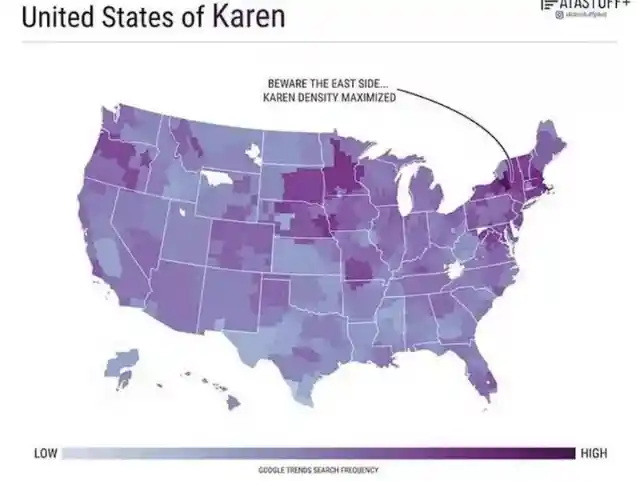

The majority of us know about this term and may even know a couple of Karens. Are there a lot of Karens in your state? Better not be one of them as arrogance will take you to international news and, of course, it’s never good to be rude to others. Kindness is a far better habit to cultivate than complaining.
Types of American Girls
There’s no limit to the fun and creativity you can have with maps. The person behind this bright map will show you why. If you need to understand what sort of American woman you are, look at this cool map. It shows who you’re likely to be, depending on your state.
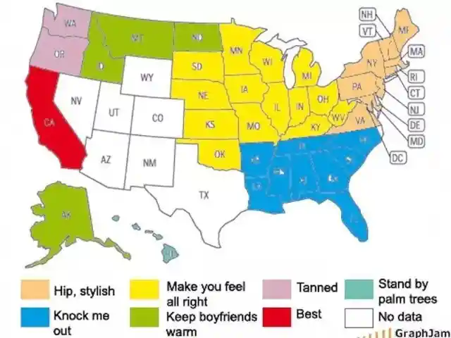

Evidently, every one of the young ladies on the East Coast is hip and stylish, while the ones from Hawaii remain close to palm trees throughout the day. We couldn’t agree more. What are your thoughts?
Stereotype Alert
We’ve seen a few of these maps all through this rundown, so there’s absolutely some overlap. Between “Hollywood, baby!” (California), “Wizard of Oz” (Kansas), and “potatoes” (Idaho), we’re telling you, this map is as annoying as you can get.
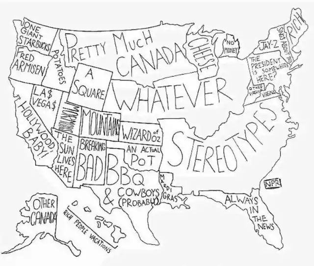

Truth be told, the individual who drew this map was so lazy they just put the word “stereotypes” for the entire South. Of course, it was all in good fun.
Designed by a Teenager
Though it’s not always the case, teenagers can often be childlike and brattish, and this map just affirms that assertion. When one mother requested her teen to design a road trip through the United States, this photograph was not what she envisioned.
Her child gave her an ordinary map, yet with a couple of changes, adding some nonexistent restroom-related areas. At least, he tried his best and we like it. A rare map of America that considers every traveler’s personal needs.
A New Slogan for Every State
On the off chance that each state got a new slogan, this map shows what they would be. Before you start to worry, these slogans are intended to be funny, so don’t get too upset about the sweeping generalizations.
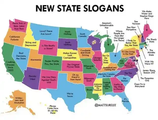

The one in particular that is truly obvious is New York’s – each New Yorker essentially believes that New York is the only significant state in the US. We’re certain that the person who designed this bright map is a loyal New Yorker.
What Each State Googles
If you were truly thinking about the main thing individuals are looking for on the web in each state, we’ve got you covered. No need to search further thanks to the person behind this map who thought and researched hard on what each state googles.
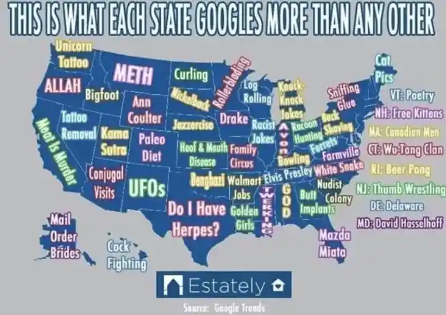
From the vibes of this map, people appear to look for an entire scope of things, from cat pics to mail-order brides. Perhaps it’s simply us, yet we’re beginning to be anxious about the residents of Texas.
Another Dad Joke
We have a feeling this won’t be the last time a dad joke pops up on this list. Just one look at the map below and you’ll see why we all rolled our eyes and groaned.

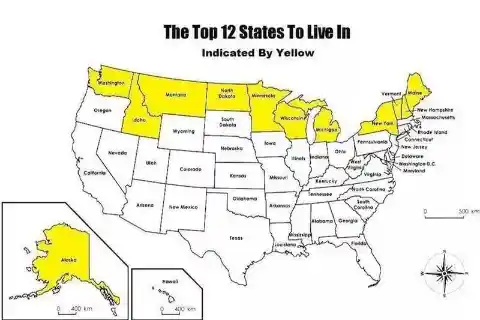
As indicated, the title of this map is “The Top 12 States To Live In.” However, if you were looking for a good state to move to for employment opportunities or raising a family, this map wouldn’t do you much good. The map-maker took the word “top” literally.
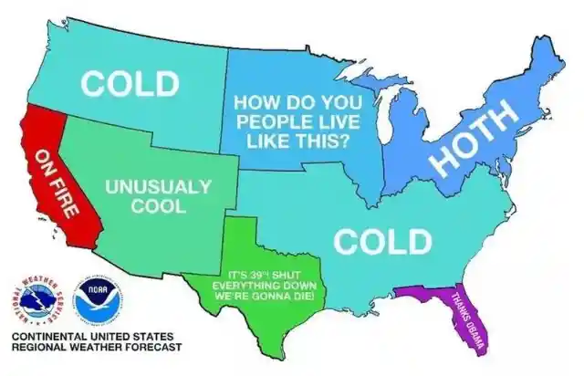
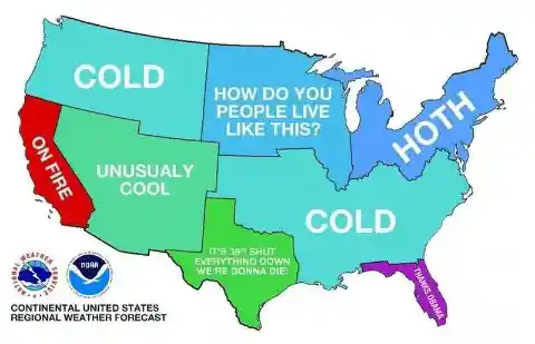
The Weather in America
This creative map is one of our top choices because it’s interesting and the graphics are astonishing! What’s more, the climate in America differs from one season to another, yet this map essentially nailed it.
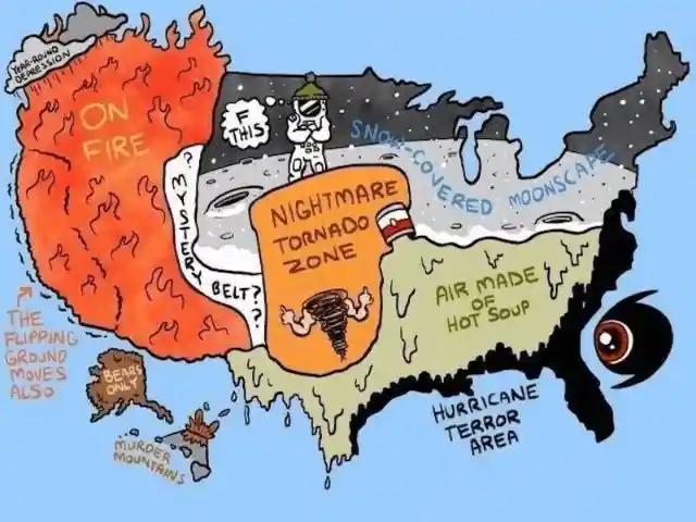

Between the snow, hurricanes, rapidly spreading fires, hot air, storms, and earthquakes, America truly has a taste of everything. Without this variety of weather, this country wouldn’t be that thrilling. However, if this is the real weather in the US, we might consider moving to another country…
Different Shades of Blue
While this map is clearly about the 50 shades of blue, we don’t understand the rationale behind it. There isn’t any explanation for why a few states are lighter or darker than others. Maybe the designer of this map wanted their output to be unique, hence the random idea.
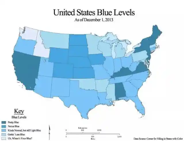

Perhaps the individual who made this was bored, and blue is his #1 color. We love the calmness and positive vibes brought by the color blue!
The Who’s Allowed Map
Tune in, everybody! We realize all of you need to have the choice of going topless whenever you visit any state in the United States, so you should save this map so you can analyze it as a source of perspective.

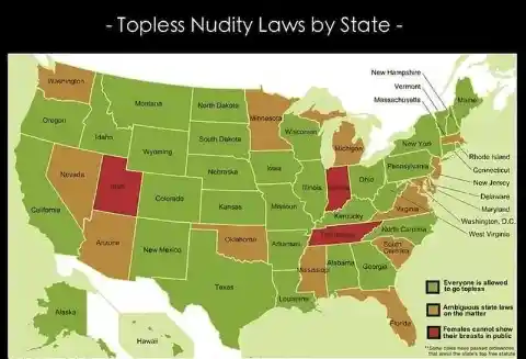
For ladies living in Utah, Tennessee, or Indiana, we deeply apologize, but you’re not going to have much luck going topless. However, the rest of the states seem pretty open to the idea. Of course, we suggest referring to actual state laws before doing anything crazy!
The Very Obvious Map
What’s the most well-known language spoken in the United States? You got it – English. We strongly believe the maker of this map had a statement they wanted to make, so they used this illustration to call attention to their views on American culture.
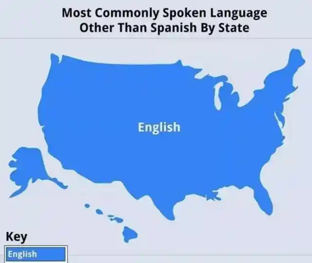
Let’s not forget that the “key” area on the lower-left corner was a hilarious touch. Also, this is one of the most random and most obvious maps on the list. Still, it does say something about diversity in the US.
A Map by Kim Jong Un
This map is called “Kim Jong Un’s Plan for America,” and the person who posted it claims it was a photograph that came directly from a North Korean war room, released a couple of years ago.
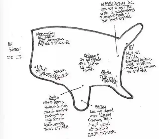
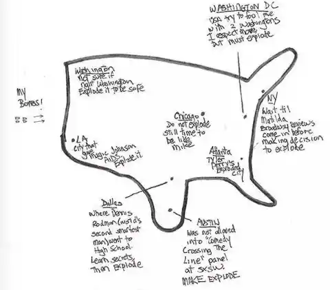
The map is clear in showing which cities the supreme leader of North Korea wanted to put down with his atomic weapons. Fortunately, this arrangement appears to be unfinished. We’ll leave it up to you to decide if you think it’s real.
The Climate Map
What does it truly take for schools to close down in your state? Everything relies upon where you reside in the United States of America because various areas of the country have unique climates.
While a few zones get freezing and blanketed with snow, like the Northeast side, the West Coast is bound to have wildfires. The people behind this map were clearly feeling a little emotional. Who wouldn’t be when your state is on fire, right?
A Map to Embarrass Your State
At first glance, this map looks fun. But when you check further, you will realize that this is a map of shame, pointing out what your state is most exceedingly terrible at. Look and learn (and please don’t be embarrassed about your state).
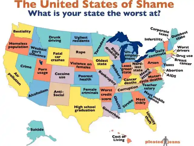
We trust that there’s no real proof to back the things written here on the grounds that the vast majority of them are totally terrible. We’d particularly feel quite awful if you lived in Louisiana or Michigan.
Nasty Town
Before you begin contemplating whether these names are genuine towns, believe us when we say that they are. Don’t be offended when your state has a nasty name. The people behind this map surely have the best intention of making their readers laugh.

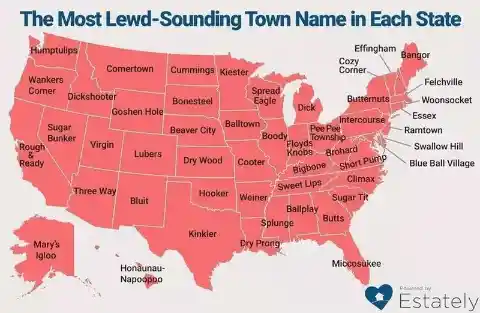
We realize it’s difficult to accept, and keeping in mind that we have no clue about why anybody would call their town Rough & Ready or Wankers Corner, someone did, and they most likely thought it was perfectly fine. We’ll concede, these names are entertaining and unique.
The Bigger Competition
Imagine if the 50 states of America had a contest to identify what thing is the largest in their state. As per this map, there is a big range between ordinary and truly insane.
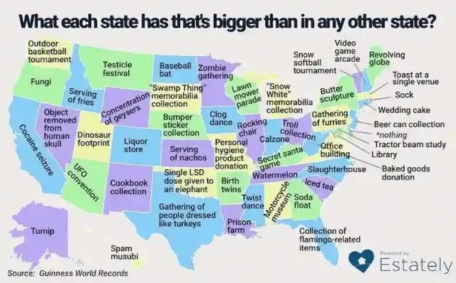
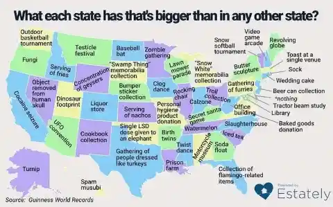
It’s interesting to note that the state of Tennessee has the biggest watermelons. However, we’re more concerned about why individuals in Texas are getting together to take on the appearance of turkeys? Did you notice that there are states with zombie gatherings and UFO conventions? Sounds cool.
The Places You Can Find Love
In case you’re hoping to discover love, it’s high time to give up Tinder since this map is much more accommodating. As indicated by this image, you can see the areas in every state that have the most “missed connections.”
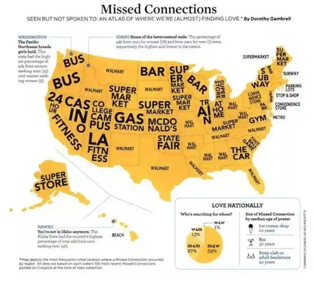

This implies that individuals saw each other but failed to speak up and ask for a date. When you’re ready to finally meet your ultimate love, we recommend checking this map first. That way, you’ll have time to prepare for your outfit. You never know whether you’ll meet the love of your life in a gas station or in Walmart.
States with Toes in Their State Flags
This guide raises a genuine point that we never thought of before, not even in our wildest dreams – how many parts of America have toes in their state flags? It turns out this is a bigger issue than you might imagine.
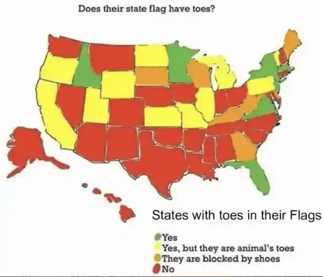

As indicated by this map, seven states have toes in their flags, while many others have animal toes or toes blocked by shoes. After careful evaluation of this map, we came to the conclusion that maybe, just maybe, the United States has a foot fetish. Do you agree with us?
Steamed Ham (aka Hamburger)
You probably watched the scene on The Simpsons, however, did you realize that this map is legit? While everybody calls bread with a meat patty a hamburger, there’s one spot in New York that called it something different. In Albany, burgers are classified as “steamed hams.” Weird but true.


We don’t understand why they would prefer naming it steamed ham. We didn’t realize there’s another name for hamburger until we saw this map. If ever we visit Albany, we’ll definitely order a bunch of steamed hams. With buns, of course!
An Australian Point of View
From what we can see in this map, it seems that Americans and Australians may share a lot in common. Specifically, geography appears to be not either one’s area of expertise.
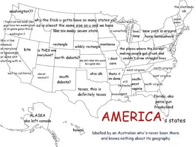

This amusing map shows how an Australian perceives America. Did they get everything right? We particularly appreciate the honesty in labels like “ohio idk,” “mississippi?” and “texas, this is definitely texas.” What could be more entertaining than having someone from a far-off land try to label all the regions of your country?
Favorite Quarantine Activity of Each State
Many people had a great deal of free time in isolation. As such, we learned a lot of things and discovered activities we didn’t think would interest us. This map shows us what people in each state were doing during quarantine.
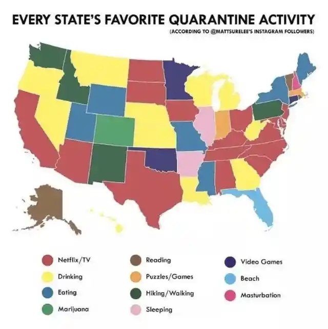

Clearly, this isn’t exact, yet the activities listed are quite relatable. Netflix and watching TV were the favorite activities of most states, and we couldn’t agree more. We’re all happy to miss an hour or two of sleep just to finish the latest trending series or movie on Netflix.
Map of Weird Food
It does not come as a surprise that Americans enjoy eating freaky-sounding food, and the food differs from one state to another. Have your kids tried scorpion lollipops? Have you and your partner feasted on gooseneck barnacles?
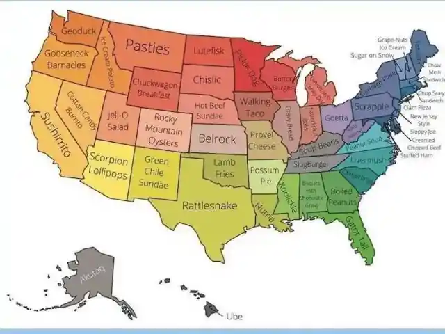

Relatively few people have tried these crazy “treats,” unless you belong to those states who enjoy eating them. We trust those slug burgers in Tennessee don’t have real slugs in them. Do you mind eating a walking taco and having a hot beef sundae for dessert? This variety of weird food sounds delectable!
Map of America’s Monsters
If you were ever inquisitive about the potential beasts that could appear in your state, this illustration will tell you about every one of their subtleties. Thanks for this marvelous creation go to artist Mark Adams, who took his inspiration from various legends that were told through the years.
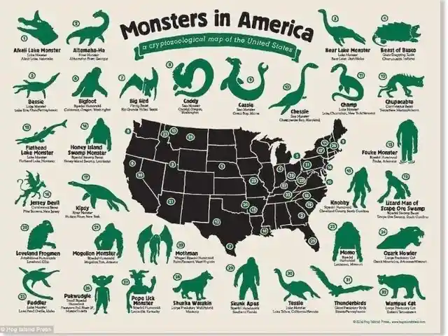
For instance, if you’re interested in exploring Louisiana, legend suggests that the Honey Island Swamp Monster (a seven-foot, ape-like creature) was seen in St. Tammany Parish. Avid monster-hunters may wish to check out this region. If you see one, please let us know, and don’t forget to take a selfie!
Map of Kevins
Have you at any point been interested in who the celebrated Kevin is from each state? Who would not like to know which Kevin from their childhood neighborhood became wildly successful? Check out this map that includes a brief description of Kevins from each state in America.
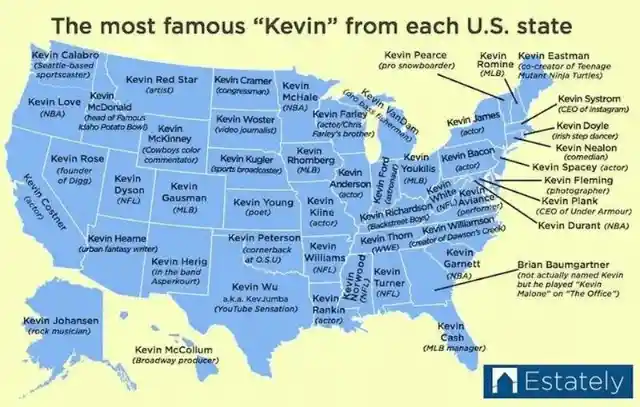

Some of them are very notable – like Kevin Bacon, Kevin Durant, and Kevin Garnett – and the most interesting one is the person who played the character Kevin on the TV series, The Office. Do you know any famous Kevin who’s not been included on the list?
A Map of the US (Sans Land)
This map is quite informative, no doubt. In any case, if you’re as yet not certain why this map is nothing but blue, the answer lies in the title. Should you have great suggestions for future maps like this, we would definitely consider them.


This map comes with a self-explanatory title: “If America Had No Land.” You can’t really argue with the logic. In the event that there was no land, there would simply be an enormous body of water. It makes sense, right?
In The Eyes of a New Yorker
New Yorkers are famous for claiming that their state is the most important one in the country. Indeed, many New Yorkers never even leave their home state. Aside from that, there are New Yorkers who don’t even spend time to think about the other 49 states in their nation. It seems they are convinced that all other regions are sub-par compared to their little homeland.
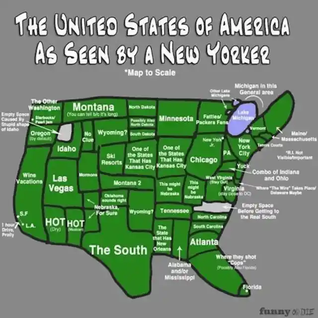

That is the very reason this map was made – for an interesting interpretation of how New Yorkers see the remainder of America. Come on, New York, show some love to your neighbors throughout the US.
Map of Secrets
We’re sure you want some juicy tattle. Check this map that unveils the biggest secrets of each state of America. Heads up! Some of these revelations are extremely embarrassing.

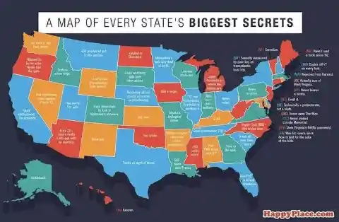
Evidently, Idaho really favors onion rings over french fries, Wisconsin is lactose intolerant, and California steals attention by faking earthquakes! This is stunning, yet it’s a good thing the truth has come out! Thanks to the team who did such good research and dedicated themselves to sharing this incredible information.
How Alaska perceives the US of A
Let’s admit it – when we studied geography in school, Alaska seemed a little, out of place. The rest of the states in America all fitted nicely together, while Alaska had to be thrown in as a kind of floating oddity that was geographically nowhere near where it actually is.
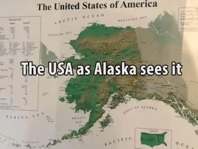
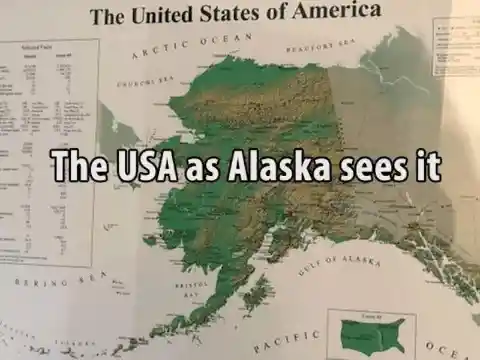
In reality, Alaska is not some small afterthought, despite how it looked on the maps posted on our elementary school walls. This map clearly asserts how Alaskans see the United States of America, and it’s pretty cute. Well, each state has its opinion, and we respect it.
If Each US State Was a TV Series
If you needed to know which television series best depicts which state, this is the map for you. Named “If Each State Was a TV Show” you’ll have the chance to discover your old neighborhood state and check whether the TV show is relevant. What do you think? Did they get it right?

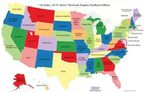
After checking all the states and their matching TV shows, we have to admit, some of them are pretty accurate. Nobody would argue with the fact that New York is a perfect match for Seinfeld or that Louisiana is totally True Blood. Are you happy with the list? Is there anything you would change?
The Famous American Pizza
This map is as precise as it is clever. Everybody realizes that the best pizza in America is found in New York. However, if you consult this map, you’ll find it’s actually the only spot in the US with great pizza. Although, the map maker has made two small concessions.

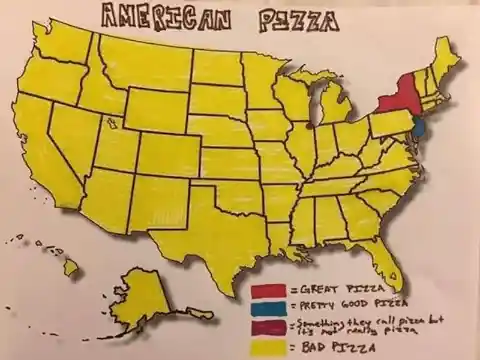
New Jersey pizza has been given the honorary title of “pretty good” (presumably because they’re so near the state of pizza perfection). Meanwhile, Chicago has been blasted for their deep-dish pizza, which we agree is nothing like a New York slice, but it still tastes pretty good.
How Brits See Americans
This one is pretty interesting – America according to the Brits. After analyzing this picture, you will discover many random facts about each area of America, but they didn’t even bother trying to include state lines.
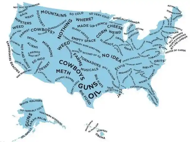
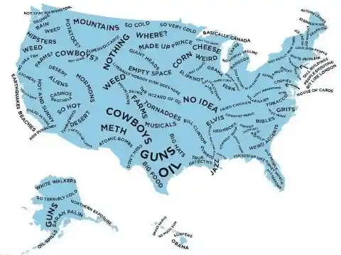
In any case, it’s not wrong that cheddar is huge in Wisconsin and Obama is from Illinois. Be that as it may, White Walkers in Alaska? At any rate, it made us giggle. Kudos to the team who came up with this fun map.
The Zombie Apocalypse Guide
Judging by all the zombie movies that have come out over the last few decades, this kind of apocalypse is a real threat to the American way of life. It’s been a subject of conversation for quite a long time, and somebody, at last, made a map featuring a zombie apocalypse survival forecast.
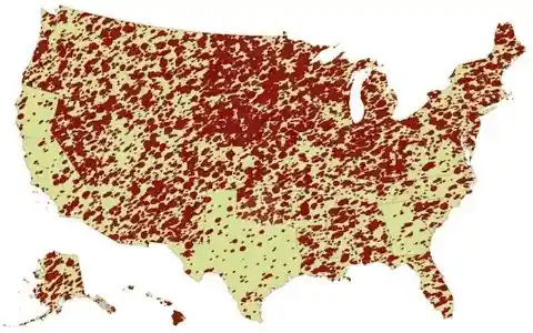
Texas and California seem to have the least carnage on the map, but in all honesty, it doesn’t look like anyone will do all that well. Of course, this is just one humble map maker’s opinion. How do you think your state would fare in the zombie apocalypse?
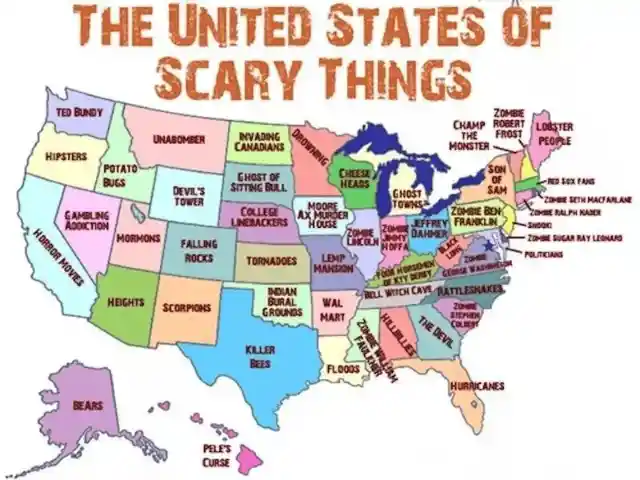
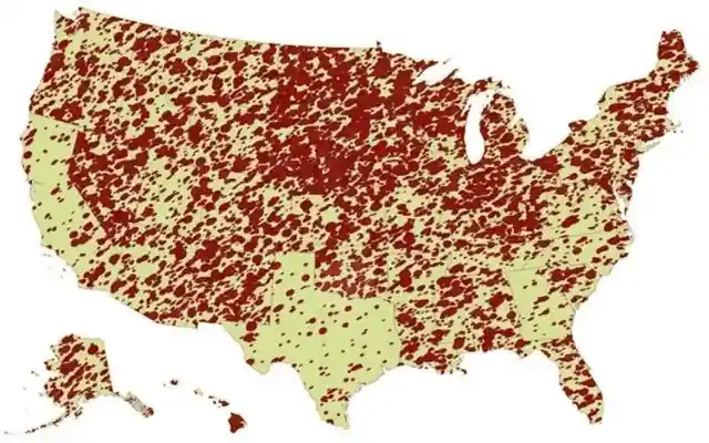
The United States of Fear
If you thought the last map was bleak and terrifying, this next one is even worse. This map illustrates all the perils that already exist in each state. One look and you may want to get started on building a bunker.


There’s nothing more startling than the hipsters of Oregon or the lobster people of Maine. Tip: Please check your state and your friends’ too. If they haven’t yet seen this helpful map, sharing it with them is the least you can do.
The Way To Rome
Are you familiar with the saying, “All roads lead to Rome?” Well, the person who designed this guide seems to have taken that assertion literally. We couldn’t be more grateful for this easy-to-follow guide.
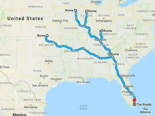
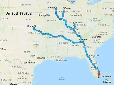
This clever map maker started at “The Roads,” a neighborhood in Miami, Florida, which split into five distinctive Rome road trips, taking you into Kansas, Illinois, Kentucky, Iowa, and Georgia. Amazing! Who wants to join us for a Rome tour of America? Don’t forget to print a copy of this map.
Checking Your Memory
This map creator surveyed people on the most and least remembered states in America, and sadly, the majority of people outside the United States don’t seem to be familiar with the Midwest (sorry midwesterners!).
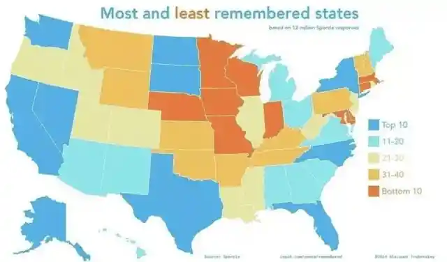
Of course, states with major cities like New York, California, and Florida are more familiar to the rest of the world. Whether you think it’s fair or not, people don’t normally consider Iowa a must-see destination when planning their first trip to the US of A.